Accession Num:
Negative Code:
Extent:
Document Date: 1950-- - 1959--
Donors: Val Morton
Creators: Val Morton
Keywords: 1950s, aerial image, Columbia River, farms, Morton Ranch, The Narrows, and Upper Arrow Lake
Locations: East Demars
Physical Description:
1 colour photograph (17.6 cm x 12.8 cm)
Notes:
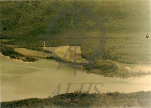
Aerial view of Morton Ranch, Lot 7106, East Demars, ca. 1950s. East is at top. South end of Upper Arrow Lake at left funneling into Columbia River Narrows at right. Inscription on rear: 'Lower end of Upper Arrow Lake, Start of Columbia River Narrows, Nakusp 7 miles north, Box Mountain to the East, Arrow Park 7 1/2 miles to the South, Saddle Mountain to the West/Land, orchard, timber, building, Mortons Sand Beech[sic] and Harbor Etcetra[sic]/S. end is 1 1/4 short of 7106-8035 boundaries approx. Lot runs approximately 3/4 inch approximately to the boundary with 7106/Lot of Acres to the south is not shown/Cedar and Fir pole and log.'
