Accession Num: 2020.007.5.34.11
Negative Code: R21-11A
Extent:
Document Date: 2001-06-07 - --
Donors: Uyeda Family Estate
Creators: Uyeda family
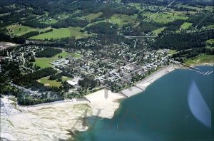
Keywords: 2000s, aerial image, Kuskanax Creek, Kuskanax Point, Nakusp Public Beach, Nakusp Recreation Park, Upper Arrow Lake, and waterfront erosion barrier (Nakusp)
Locations: Glenbank and Nakusp
Physical Description:
1 colour negative (35 mm)
Notes:
Aerial view of Nakusp (centre left to centre) and Glenbank (top) looking northeast, from above Upper Arrow Lake, 7 June 2001. Kuskanax Creek delta at bottom right next to Nakusp Recreation Park and Nakusp Public Beach. Downtown Nakusp at centre.
