Accession Num: 2018.027.9.2
Negative Code: P24-19
Extent:
Document Date: 1967-12-11 - --
Donors: Wilf Hewat
Creators: Wilf Hewat
Keywords: 1960s, aerial image, Arrow Lakes flooding (Columbia River Treaty), BC Hydro, Bluffs Forest Service Road, Broadwater Road, Columbia River, dam, dam construction, Hugh Keenleyside Dam, and Lower Arrow Lake
Locations: Castlegar and Robson
Physical Description:
1 colour slide (35 mm)
Notes:
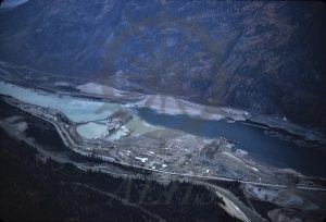
Aerial view, High Arrow Dam (later Hugh Keenleyside Dam) under construction, Columbia River west of Robson, 11 December 1967. North is at bottom left. Broadwater Road runs left-to-right through image at bottom.
