Accession Num: 2018.027.7.22
Negative Code: P24-2
Extent:
Document Date: 1969-09-16 - --
Donors: Wilf Hewat
Creators: Wilf Hewat
Keywords: 1960s, aerial image, dam, dam construction, Highway 37 (Montana), Kootenay River/Kootenai River, Libby Dam, National Forest Development Road 228, Souse Gulch Road, US Army Corps of Engineers, and Warland Road
Locations: Jennings (Montana)
Physical Description:
1 colour slide (35 mm)
Notes:
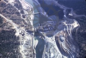
Aerial view, Libby Dam under construction, Kootenai River north of Jennings, Montana, 16 September 1969. North is at bottom. Warland Road crosses Kootenai River to south of dam at top left. Montana Highway 37 at left. National Forest Development Road 228 at top right. Souse Gulch Road and Libby Dam Visitor Center immediately to top right of dam below Road 228.
