Accession Num: 2023.009.015
Negative Code: R29-15
Extent:
Document Date: 1968-07- - --
Donors: Diane Rabchak and Trail Museum & Archives
Creators: Albert Elwin Anderson
Keywords: 1960s, Anderson; Albert Elwin, Arrow Lakes flooding (Columbia River Treaty), automobiles, Grassy Point, Highway 6, and Lower Arrow Lake
Locations: Fauquier
Physical Description:
1 photograph : col. slide ; 35 mm
Notes:
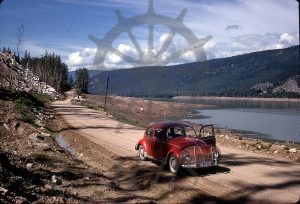
Photographer Albert Anderson's Volkswagen Beetle parked on the original alignment of Highway 6 at Grassy Point north of Fauquier alongside The Narrows of the Columbia River, July 1968. Much of the valley bottom has already been cleared in advance of flooding to be created by the Hugh Keenleyside Dam. The scar from the 1953 Whatshan powerhouse slide is visible at back centre right. Photo by Albert Elwin Anderson, Trail.
