Accession Num: 1999.019.36
Negative Code: M2-17
Extent:
Document Date: 1970-04-21 - --
Donors: Estate of Jean Spicer
Creators: Jean Spicer
Keywords: 1970s, Arrow Lakes flooding (Columbia River Treaty), farms, Nakusp Public Wharf, Rothwell Bay, Rothwell Point, Spicer Farm, Upper Arrow Lake, and waterfront erosion barrier (Nakusp)
Locations: Nakusp
Physical Description:
1 colour image (35 mm)
Notes:
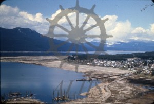
Bird's-eye view of Nakusp townsite and Rothwell Point taken from Nakusp & Slocan Railway lookout, 21 April 1970. Remains of original Highway 6 right-of-way at centre. Remains of original Spicer Farm at right
